Sir Gawain and the Green Knight
The Green Chapel
To contact us by email click the button
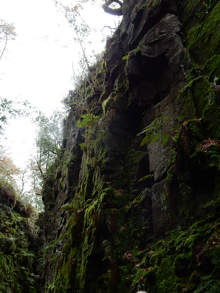
LUDCHURCH
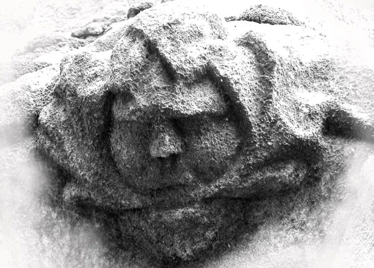
What was the green chapel? we know it was ‘nobut ‘an old cave, or a crevice in an old rock. As for its location, we know it was beside a ‘grove’, a high forest grown for timber. Ludchurch was once on the edge of a high forest, high forest farm is just a few hundred yards away. Ludchurch is in an area called back forest, on the boundary of Leek frith, just above the high forest.
‘Back’ in Nordic means hillside; slope; Old Norse, bakki: slope; river bank. Back forest is on a slope or hillside, ascending from Black brook and the river Dane.
Lud (1) in Old English/Anglo-Saxon, also means ‘back’, as Ludgate in London, which probably derives from the Old English word ‘ludgeat’, meaning ‘back gate’. From Middle English Dictionary: Lud-gate (n.) Also lodgate. OE: lud-geat a postern. Ludchurch is in the Back forest.
Lud (2) from MED: loud (adj.) Also loude, loued, lud(e, lut & (in place names) ludd , lodde, lode; i.e. in place names, in names of rivers and streams [see Smith PNElem. 1.253]. Ludebeche and Ludebrok are the bounds of lands given to Dieulacres abbey by the Earl of Chester.
Ludd (3) (Nuada or Nudd) was the Celtic god of healing. He was reputed to use his sword to cut his enemies in half. According to Celtic mythology, when Nuada was killed, Lugh became the leader of the Tuatha de Danaan, the term used for those who were descended from the goddess Danu. The god Lugh (Ludd) was worshipped in Ireland as a deity of the sun. The name means “shining one”. However, at this time we apparently have no evidence of a link (to Ludchurch). See www.leekfrithhistory.org.uk
Lud (4) Legends of the Moorlands and Forest in Staffordshire (1860) – During the reign of James II Sir William de Lacy visited the cavern of Lud Church. The Legend of Lud Church describes a Lollards meeting conducted by Walter de Lud-auk in the early 1400s. During the meeting the Grandaughter of Lud-auk was killed by law officers attempting to arrest the Lollards.
Church (n.) Old English cirice, circe “church, public place of worship; Christians collectively,”
from West Germanic *kirika (cf. Old Saxon kirika, Old Norse kirkja, Old Frisian zerke,
Middle Dutch kerke, Dutch kerk, Old High German kirihha, German Kirche).
Chapel (n.) early 13c., from Old French chapele (12c., Modern French chapelle), from Medieval Latin cappella
“chapel, sanctuary for relics,” literally “little cape,” diminutive of Late Latin cappa “cape” (see cap (n.));
by tradition, originally in reference to the sanctuary in France in which the miraculous cape of St. Martin of Tours,
patron saint of France, was preserved; meaning extended in most European languages to “any sanctuary.”
Green (n., adj.) Old English grene “green, young, immature, raw,” earlier groeni, from West Germanic *gronja-
from PIE root *ghre- “grow” (see grass), through sense of “color of living plants.”
Meaning “a field, grassy place” was in Old English.
Hit hade a hole on þe ende and on ayþer syde,
And ouergrowen with gresse in glodes aywhere,
And al watz holȝ inwith, nobot an olde caue,
Or a creuisse of an olde cragge, he couþe hit noȝt deme
with spelle.
Ludchurch does seem to fit the poet’s description, with a hole at the end and on either side, and overgrown with grass in clumps everywhere, within it was hollow just like an old cave, or was it a crevice in an old rock, he could not say which it was.
BOUNDARIES
‘Hit hade a hole on þe ende…..’
This may be the cave in Ludchurch (now blocked) is at its southern end, past the flight of steps leading out of the place.
We have a cave/crevice then which may fit the poet’s description but where is it located? The poet tells us that it is on a boundary, a ‘mere’ a forest boundary.
The principal meaning of OE (ge)mǣre is “boundary”.
Gawain enquires of Bertilak where he could find the green chapel,
Of þe grene chapel, quere hit on grounde stondez,
And of þe knyȝt þat hit kepes, of colour of grene.
Þer watz stabled bi statut a steuen vus bytwene
To mete þat mon at þat mere, ȝif I myȝt last;
‘of the Green Chapel, where it stands on the ground, and of the knight that it keeps, of colour of green.
There was established an appointment by agreement between us, to meet that man at that mere, if I might last;’
Gawain first enquires where the Green chapel is located as he passes through the forest of Wirral. The boundary of the Wirral on its eastern side is the river Mersey, Mersey meaning ‘boundary river’. But the men he met on his travels through this area, had not heard of any talk of the Green Chapel.
As we have seen the Gawain poet knew the forest well, he understood the terms used to describe its flora and fauna.
‘Mere’ in foresters language meant the boundary of the forest: meer, mere – boundary mark (P 205); boundary often delineated by mere stones (the word is also used to refer to a pond) (R 168); markers or meres of forest boundaries, which though open were ‘as if they were a brick wall’, belonged to the king and were irremovable, known by record (perambulation) or prescription (M 10 (v) – 11 (r)). See ‘bounds’. From, Forests and Chases in England and Wales, c. 1000 to c. 1850; A Glossary of Terms and Definitions.
In ‘The poems of the pearl manuscript’ edited by Andrew and Waldron, mere is interpreted as rendevous. Although mere was a rendevous place where Gawain would meet the green knight, I believe our forester poet was refering to the edge of the forest, its boundary. Of course Gawain did not know where the Green chapel was so how could he say it was at the boundary of the forest. Gawain has a preconcieved idea that the green chapel is on the edge or boundary of a wooded forest. Perhaps the poet’s local audience knew of the green chapel and its location on the boundary of the forest, ‘Þe knyȝt of þe grene chapel men knowen me mony;’.
There are other references to boundaries in the poem associated with the green chapel:-
‘Bi a forȝ of a flode þat ferked þare;’ (By the furrow of a stream that passed there;) indicates a possible boundary mark.
The green chapel is next to a forest boundary as suggested by the Gawain poet’s ‘mere’, also Gawain’s servant escorts Gawain to the edge of the forest, beside the grove. As we have seen, the grove would be the high forest of ‘hore’ oaks Gawain described as he first entered the forest ‘full deep’.
‘Hore/hoar’, as well as meaning grey, hoar-frosted or ancient, can also indicate a boundary.
‘To mete þat mon at þat mere, ȝif I myȝt last;’
‘A balȝ berȝ bi a bonke þe brymme bysyde,
Bi a forȝ of a flode þat ferked þare;’
Boundary refs., extracts from English Place-Name Elements Relating to Boundaries by Boel Jepson, Centre for Languages and Literature, Lund University 2011: download here, https://lup.lub.lu.se/luur/download?func=downloadFile&recordOId=2167199&fileOId=2167202
Cheshire: Merebroc 1270 (17) Sheaf (PNCh 1:187). _ le Merebroc inter Halton‟ et Clifton c. 1275 Chol (PNCh 2:172). _ Merebroc 13 Dieul (PNCh 3:3 f).100 _ le Merebrock 1307 AddCh, the Mear brook 1590 (1680) Sheaf (PNCh 2:161 f).
in the following, ‘Old English’ usually refers to Anglo-Saxon
Old English, furh “furrow‟:
OE furh: “Of course it means a furrow. In the charters it is used of what was evidently a furrow drawn to an unusual breadth to form a boundary between ploughlands.” Grundy (1922a:56).
Examples:
Nottinghamshire: (on) ϸa mær furh
Wiltshire: (æt) mær furh 940 (14th)._ (and lang) mær fyr 901 BCS 595. _ (on) ϸe mere fourh 940 BCS 752.
East Riding Yorkshire: Merefures 1260 (PNERY 323: “… Merefures (1260) i.e. boundary-furrows, from OE (ge)mære”).
Old English, flōde “intermittent spring or stream, gutter‟: (this occasional stream may only have ran if there was heavy rain or melting snow).
Examples:
See PNWRY: “v. flōde “gutter‟, rān “boundary strip‟ ”.
Berks: (to) mærfloden 939 (c. 1240) BCS 743 (S 448), (to) mær flodan c. 935 (c. 1200). “intermittent spring on the boundary‟, v. (ge)mǣre, flōde.
Also of interest in this book: “THREE SHIRE HEADS, (111-009685), the Three Sheres 1533 Db 373, the (three) shire stones c. 1620 Orm2, The Three Shire Mears 1656 ib., “the three county-boundary stones”, where Cheshire, Derbyshire and Staffordshire meet, v. ϸrēo, scīr, hēafod, stān, (ge)mǣre.”.
Concerning the hore oaks in the poem, the poet mentions that:
‘Of hore okez ful hoge a hundreth togeder;
Þe hasel and þe haȝþorne were harled al samen,
With roȝe raged mosse rayled aywhere,’
See Duignan, Worcestershire Place Names (1905:83): “HOARSTONE. A. S. hār (pron. hoar) plays an important part in pl. names. All dictionaries translate it “hoary, grey, old,” and that undoubtedly is one of its meanings; but it certainly came to be used, at a very early period, in the sense of “boundary”; it is one of the commonest words to be found in the charters, generally in its dative form hāran; always on a boundary, and always in that obvious sense; yet it has been perversely translated “grey,” _ the “grey oak,” the “grey withy,” the “grey pit,” etc….
Jepson, after providing arguments for and against ‘hoar/hore/hār’ meaning a boundary, concludes that, ‘I hope that the material will throw some light on the nature of the relation, which no doubt exists, between hār and boundaries.’
In Jepson’s book we are told, Boundary marks and territory would tend to be left undisturbed for fear of trespass, and an unbroken wood or an untouched boundary stone would grow mossy, venerable and “hoary” with age.
Ranulph of Chester helps to plough a boundary furrow, marking land given to Dieulacres abbey by Richard, lord of Aldford (see, The Audleys)
Bunde int Byley et Rudheath
These boundaries rode Ranulph, earl of Chester, who gave seisin to the abbot of Dieulacres in Rudheath, after the exchange made with Richard, lord of Aldford; beginning, &c.
And he made three ploughs to plough deeply after him. And when they did not plough deeply, he dismounted from his palfrey and with his little breast (the earl was said to be of dwarfish stature) he pressed upon the ploughs that more widely (deeply?) they might cut. The charter of that grant and seizin was read before lord Pagan Tibtolt, justice of Chester, by the hand of John the friar of Tutbury, in full county (court) of Chester. All these things witnessed and heard Simon de Dudleston who held one plough of the said three when they ploughed and bounded. – from John Sleigh’s History of Leek.
Sir John Chandos was granted £40 annual rent from Rudheath, in 1357 (ibid., 231, 267).
The bounds of the lands given to build Dieulacres abbey upon, are described as follows, from John Sleigh’s History of Leek:
” All Rudyerd (to be disafforested, and an abbey built there*) by these bounds: by the water of Ludebeche, which flows between Rudeyard and Lech, as far as the house of Radulph Bec; thence to Merebrok, (mentioned as a boundary earlier) and thence as far as as Quamendehull, and thence descending by the house of Dodin to the sepulchre of Thoin; and thence to Falinbrok, and by F. till Fulhe, and thence to Ludebrok. Witnesses, William de Ferrars, earl Derbye, John, earl of Huntedon, Walter de Deyvill, Richard de Burun, and Simon the priest.”
* The land surrounding the abbey would become a private forest , a frith, for the use of the abbot of Dieulacres
In the description of the bounds of the lands ‘Lude’ is mentioned twice, ‘Ludebeche’ and ‘Ludebrok’. Both these names refer to streams so probably means ‘loud’, a loud beck and a loud brook, see Lud (2) above.
As Gawain approaches the green chapel, he describes it as an ancient burial mound, ‘a sort of mound, a smooth-surfaced barrow.’
Barrows were frequently used as boundaries, from English Place-Name Elements Relating to Boundaries by Boel Jepson.
Forsberg 1973:8 (discussing Ætstealles beorh in an OE boundary survey): “A barrow, in addition to being a very prominent landmark, would enable a point on the boundary to be defined with considerable precision and may be expected to have been chosen for the purpose when conveniently situated.”. The nature of the relation between barrows (and burial cairns) and boundaries is, however, uncertain. Perhaps it varied. See Faull (1979:27): “It is not certain whether the association of barrows and burial cairns with boundaries found in some parts of England is the result of an already existing site being utilised as a convenient boundary marker, or whether the burial had been placed on the boundary deliberately. Dr. Bonney has shown that in southern England pagan Anglo-Saxon burials seem to have been placed on pre-existing boundaries after which they in turn became boundary markers.”, and see also Pantos (1999:108): “[…] since mounds may have been built along boundaries as markers, or the boundaries themselves set out with reference to earlier features such as tumuli.”.
All of the above information does suggest that the poet really did mean to indicate that the green chapel was on a forest boundary: ‘To mete þat mon at þat mere, ȝif I myȝt last;’. Also that the location of the Green Chapel was known to some of the poet’s audience: ‘Þe knyȝt of þe grene chapel men knowen me mony;’.